Home > Website Guide
Welcome to caribbeanweather.org! Your one stop website for everything weather related in the Caribbean and surrounding areas! With over 16 sections and dozens of web pages, we've sourced and put together - all in one website - some of the best and latest weather related information, images and forecasts. This site has been built for weather enthusiasts, amateurs, professionals and everyone in between!
If you are new to our site, here is what you'll find:
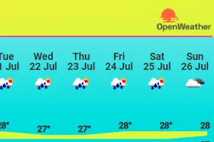
In this section, you'll find information on the current weather, as well as forecasts, for 20+ countries in the Caribbean region (Source: OpenWeather and meteoblue).

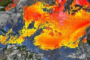
In this section, you will find dozens of satellite images for the Caribbean, Puerto Rico, the Gulf of Mexico, the United States Atlantic Coast, the Tropical Atlantic and the Western Hemisphere. In total, there are 60 different sallite images (Source: NOAA). You'll also find satellite images of Western Africa (Source: EUMETSTAT METEOSAT).

In this section, you will find links to a few websites that provide radar images for the Caribbean, Puerto Rico, and South Florida (Source: Various).
In this section, you'll find images depicting the Saharan Air Layer. One image is focused on the Americas and Caribbean and the other is focused on Western Africa (Source: CIMSS, University of Wisconsin-Madison).
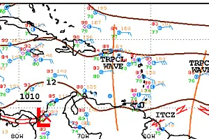
In this section, you will find surface analysis charts. Surface Analysis charts are visual representations of weather conditions at the Earth's surface. These charts show atmospheric pressure patterns, fronts, and other weather systems on a two-dimensional map. In this section, you'll find charts for the Caribbean, Gulf of Mexico, Western Atlantic and a wide area chart covering the entire Atlantic Ocean and parts of the Pacific Ocean (Source: NOAA NHC).

Do you live, work or play in or near the sea? Are you a sailor, surfer or fisherman? This section might be for you! This section features wind and wave charts as well as high sea forecasts (Source: NWS/NHC).
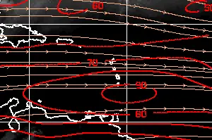
Wind shear plays a significant role in the development and intensity of tropical storms, including hurricanes. In this section, you'll find images relating to North Atlantic wind shear (Source: UW-CIMSS/NESDIS).

Reynolds Sea Surface Temperature (SST) Charts are used by scientists, researchers and other interested parties, to track and analyze changes in sea surface temperatures over time. Sea surface temperatures can affect the strength and intensity of storms as they cross the Atlantic ocean (Source: NWS/NOAA).
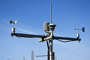 In this section, you'll find the latest weather observation data (including but not limited to wind speed, sky conditions, temperature, and relative humidity) for over
20 locations across the Caribbean region (Source: NWS/NOAA).
In this section, you'll find the latest weather observation data (including but not limited to wind speed, sky conditions, temperature, and relative humidity) for over
20 locations across the Caribbean region (Source: NWS/NOAA).

While not weather related, this section displays the latest information on earthquake activity in the Caribbean region (Source: USGS).
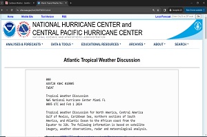
Atlantic Tropical Weather Discussion
In this section, you'll find current information on major weather patterns and disturbances in tropical regions (Source: NHC).
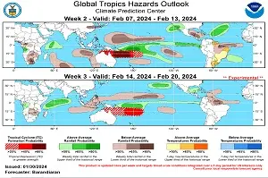
Global Tropical Hazards Outlook
In this section, you'll find the Global Tropical Hazards Outlook. The outlook predicts what's likely to happen in the next two to three weeks in The Tropics (in terms of rainfall, temperature, tropical storms). The outlook covers large areas and doesn't focus on specific local conditions (Source: NWS Climate Prediction Center).
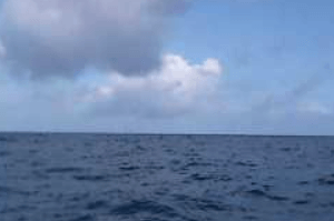
In this section, you'll find imags from buoy cameras that are placed in the Caribbean Sea, Gulf of Mexico and The Atlantic (Source: NDBC/NOAA).

In this section, you'll find a hand compiled list of webcams that we've found across the Caribbean. These cameras are especially useful during bad weather as some of them - assuming they are operational - can give viewers a taste of bad/inclement weather without being in the middle of it! (Source: Various).

Finally, in this section, we've compiled what we believe to be a list of useful website links and resources (Source: Various).
Join our official Facebook group for updates and more! Connect with fellow weather enthusiasts today!